With improving transport systems and more densely populated cities, we need to have a method of understanding how sars-cov-2 and other diseases spread through populations with increasing accuracy. When there is a better understanding of how a virus spreads then better measures can be put into place to reduce the spread of the virus and decrease the number of fatalities that occur. One method is the use of geospatial social networks to create agent-based models which can inform contact tracing.
Contact tracing requires an individual who has tested positive for a disease to report their recent contacts, so that those people can self-isolate to prevent the further spread of the disease. It has proven very effective and was used as a primary method of controlling the spread of Ebola. Contact tracing is even more effective with Coronavirus due to the spread of the pathogen happening when people are still asymptomatic; effectively tracking people interactions can be key in mapping and suppressing its transmission. Since contact tracing is based around the interactions of potentially infected people, simulations can be used to inform of how likely interactions are to spread the disease and the effect of reducing interactions.
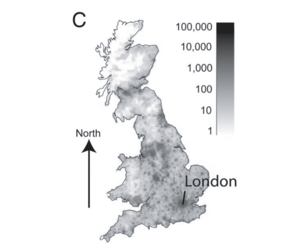
At the moment most simulations for contact tracing focus on a single space, such as a city, where the population density could be considered homogenous. The simulations aren’t as accurate when used at scale where population densities cannot be considered homogenous. Even at small scale they can’t currently account for spatial factors, such as distance between people, and can only account for transmission within defined locations such as workplaces.
Scientists run the simulations using different policies, such as quarantining people or lockdown, to see which would be most effective at preventing the spread of the disease based on interactions.
Geospatial simulation looks to build on the idea of using simulations to inform contact tracing by using spatial agent-based models to represent non-homogenous populations.
It uses population density data to create synthetic social networks (e.g. workplaces, households) which respect the spatial distribution of agents in the network. It then simulates interaction between agents to model disease spread on this network. It also simulates “random” spatial interaction, i.e. disease transmission between socially unrelated agents based on only spatial proximity.
Hadean Simulate is a library which can be used to easily create spatially partitioning agent-based models. Embedding the network in space makes the simulation closer to reality, better reflecting the distribution of interaction by taking into account regional variations in population density.
One of the biggest advantages of geospatial simulations is that they can better predict the use of regional responses, such as only placing a single city with a high number of cases on lockdown. This helps to control a disease without the need for whole country lockdowns for extended periods of time.
Furthermore, it can better account for geographical clusters, where, for example, people from the same workplace would most likely live within a certain distance of their workplace. This means that colleagues’ network of social interactions are more likely to overlap, which is very important within contact tracing as this means less people may be infected than previously modelled. Lastly it can model with better accuracy how a virus could initially enter a country, accounting for if the epicentre occurs in a low population density area or a high.
Looking forward, Hadean Simulate could be used to build a geospatial social network simulation for the entirety of the UK. Tracing interactions for an entire country can improve how disease spread can be controlled and tracked. This form of modelling is needed to inform contact tracing systems such as the NHS Test and Trace. Simulations that inform contact tracing can only effectively control the spread of a virus if they run at massive scale.
With improving transport systems and more densely populated cities, we need to have a method of understanding how sars-cov-2 and other diseases spread through populations with increasing accuracy. When there is a better understanding of how a virus spreads then better measures can be put into place to reduce the spread of the virus and decrease the number of fatalities that occur. One method is the use of geospatial social networks to create agent-based models which can inform contact tracing.
Contact tracing requires an individual who has tested positive for a disease to report their recent contacts, so that those people can self-isolate to prevent the further spread of the disease. It has proven very effective and was used as a primary method of controlling the spread of Ebola. Contact tracing is even more effective with Coronavirus due to the spread of the pathogen happening when people are still asymptomatic; effectively tracking people interactions can be key in mapping and suppressing its transmission. Since contact tracing is based around the interactions of potentially infected people, simulations can be used to inform of how likely interactions are to spread the disease and the effect of reducing interactions.
At the moment most simulations for contact tracing focus on a single space, such as a city, where the population density could be considered homogenous. The simulations aren’t as accurate when used at scale where population densities cannot be considered homogenous. Even at small scale they can’t currently account for spatial factors, such as distance between people, and can only account for transmission within defined locations such as workplaces.
Scientists run the simulations using different policies, such as quarantining people or lockdown, to see which would be most effective at preventing the spread of the disease based on interactions.
Geospatial simulation looks to build on the idea of using simulations to inform contact tracing by using spatial agent-based models to represent non-homogenous populations.
It uses population density data to create synthetic social networks (e.g. workplaces, households) which respect the spatial distribution of agents in the network. It then simulates interaction between agents to model disease spread on this network. It also simulates “random” spatial interaction, i.e. disease transmission between socially unrelated agents based on only spatial proximity.
Hadean Simulate is a library which can be used to easily create spatially partitioning agent-based models. Embedding the network in space makes the simulation closer to reality, better reflecting the distribution of interaction by taking into account regional variations in population density.
One of the biggest advantages of geospatial simulations is that they can better predict the use of regional responses, such as only placing a single city with a high number of cases on lockdown. This helps to control a disease without the need for whole country lockdowns for extended periods of time.
Furthermore, it can better account for geographical clusters, where, for example, people from the same workplace would most likely live within a certain distance of their workplace. This means that colleagues’ network of social interactions are more likely to overlap, which is very important within contact tracing as this means less people may be infected than previously modelled. Lastly it can model with better accuracy how a virus could initially enter a country, accounting for if the epicentre occurs in a low population density area or a high.
Looking forward, Hadean Simulate could be used to build a geospatial social network simulation for the entirety of the UK. Tracing interactions for an entire country can improve how disease spread can be controlled and tracked. This form of modelling is needed to inform contact tracing systems such as the NHS Test and Trace. Simulations that inform contact tracing can only effectively control the spread of a virus if they run at massive scale.